Trail Quad Les Avenières Veyrins-Thuellin - bûcherons  parc avec Didier - Photo
© OpenStreetMap contributors
Length
Length
100 km
Max alt
Max alt
449 m
Uphill gradient
Uphill gradient
1710 m
Km-Effort
Km-Effort  
123 km
Min alt
Min alt
204 m
Downhill gradient
Downhill gradient
1666 m
Boucle
Boucle
No
Creation date :
2021-11-07 06:07:20.641
Updated on :
2021-11-07 13:48:07.94

(1 Reviews)

Quad
Quad
4h00
Difficulty : Easy

Scan this QR Code to open this trail in the SityTrail application

FREE GPS app for hiking

Logo SityTrail SityTrail

IGN / Geographical institutes

Download SityTrail from the App Store Download SityTrail from Google Play

Logo SityTrail SityTrail World

The world is yours!

Download SityTrail from the App Store Download SityTrail from Google Play Download SityTrail on Huawei AppGallery

About

Trail Quad of 100 km to be discovered at Auvergne-Rhône-Alpes, Isère, Les Avenières Veyrins-Thuellin. This trail is proposed by Fabrice Vernay.

Elevation profile

Positioning

Country:
France
Region :
Auvergne-Rhône-Alpes
Department/Province :
Isère
Municipality :
Les Avenières Veyrins-Thuellin
Location:
Unknown
Start:(UTM)
697809 ; 5055755 (31T) N.

Comments

Please log in to post a review or rate the element


Trails nearby

Trail Walking Corbelin - Boucle au départ de corbelin  - Photo
Walking
choubaka77

Walking

Easy
Corbelin, Auvergne-Rhône-Alpes, Isère, France
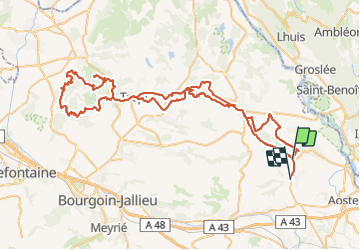
11.5 km | 14.3 km-effort
2h 41min
Yes
Trail 4x4 Les Avenières Veyrins-Thuellin - bûcheron parc avec Tim savoyard.  - Photo
4x4
Fabrice Vernay

4x4

Difficult
Les Avenières Veyrins-Thuellin, Auvergne-Rhône-Alpes, Isère, France
96 km | 118 km-effort
3h 40min
Yes
Trail Quad Les Avenières Veyrins-Thuellin - inondation - Photo
Quad
Fabrice Vernay

Quad

Very easy
Les Avenières Veyrins-Thuellin, Auvergne-Rhône-Alpes, Isère, France
26 km | 29 km-effort
47min
No
Trail Quad Les Avenières Veyrins-Thuellin - piste de débardage - Photo
Quad
Fabrice Vernay

Quad

Difficult
Les Avenières Veyrins-Thuellin, Auvergne-Rhône-Alpes, Isère, France
107 km | 143 km-effort
4h 44min
No
Trail Equestrian Brégnier-Cordon - Rallye Ain J1 - Photo
Equestrian
xhakon

Equestrian

Very easy
Brégnier-Cordon, Auvergne-Rhône-Alpes, Ain, France
26 km | 37 km-effort
4h 38min
No
Trail Cycle Vézeronce-Curtin - de vezeronce-curtin à la via rhona  - Photo
Cycle
yoann150

Cycle

Easy
Vézeronce-Curtin, Auvergne-Rhône-Alpes, Isère, France
32 km | 35 km-effort
2h 14min
Yes
Trail Mountain bike Les Avenières Veyrins-Thuellin - Chateau de la Barre à Brégnier-Cordon - Photo
Mountain bike
tracegps

Mountain bike

Difficult
Les Avenières Veyrins-Thuellin, Auvergne-Rhône-Alpes, Isère, France
27 km | 31 km-effort
1h 46min
Yes
Trail sport Brégnier-Cordon - 6-circuit-des-caves-et-des-fours-du-bas-bugey-3-jours 4 - Photo
sport
maxbfd

sport

Very easy
Brégnier-Cordon, Auvergne-Rhône-Alpes, Ain, France
22 km | 31 km-effort
Unknown
No
Trail Quad Dolomieu - reco - Photo
Quad
antholps

Quad

Very easy
Dolomieu, Auvergne-Rhône-Alpes, Isère, France
89 km | 103 km-effort
2h 46min
Yes


Close
My subscriptions